Summary
Editor's rating
Is it worth the money once you add charts and subscription?
Chunky, floaty, and very much built for wet hands
Battery life: long-lasting, but real numbers are lower than the brochure
Built to be abused, but not indestructible
GPS accuracy, marine features, and inReach in real use
What the GPSMAP 86i actually does (and doesn’t do)
Pros
- Floats and is properly waterproof, with a bright 3-inch screen usable in full sun
- Reliable GPS performance and good integration with Garmin chartplotters and autopilots
- Built-in inReach satellite messaging and SOS for real offshore safety, assuming you pay for a plan
Cons
- High overall cost once you add BlueChart g3 charts and inReach subscription
- Bulky, button-based interface with a learning curve and no user-replaceable batteries
Specifications
View full product page →| Brand | Garmin |
A floaty safety net for when things go wrong offshore
I took the Garmin GPSMAP 86i out for a few weekends on a small sailboat and a friend’s fishing boat, mainly as a backup to the fixed chartplotter and for the inReach SOS side. I’m not a professional skipper, just a fairly cautious boater who likes having redundancy when we’re a bit far from shore. That’s exactly how I treated this thing: not as my main navigation brain, but as the “if everything else dies, I still have this” device.
What struck me first is how focused it is on being a marine backup tool more than a general hiking GPS. It floats, it’s bright in the sun, and it talks to other Garmin marine gear. The inReach messaging and SOS are clearly the headline, but in practice I actually used it more to check position and speed when I didn’t want to be glued to the helm screen. It’s basically a safety blanket that also happens to be a decent handheld GPS.
Over a few trips, I played with most of the features: paired it to a Garmin chartplotter, tested the boat data streaming, sent some satellite texts, and left it on for long stretches to see how the battery holds up. I also deliberately dunked it in the water next to the dinghy to see if it really floats and if the screen is still readable afterwards. Short version: it does float, it does survive, but it’s not perfect in terms of ergonomics and setup.
If you already live in the Garmin ecosystem, this thing makes much more sense than if you’re starting from zero. It’s not cheap, and the satellite subscription is extra, so you really need to value the SOS and two-way messaging to justify it. As a pure GPS for casual day boating, there are cheaper ways to do it with a phone and a waterproof case. As a backup navigation tool with real emergency capability, it starts to feel more reasonable.
Is it worth the money once you add charts and subscription?
This is where things get a bit mixed. The GPSMAP 86i itself is not cheap, and the headline features—BlueChart g3 charts and inReach satellite messaging—both add ongoing or extra costs. If you buy it and then realize you still need to pay for charts for your area plus a monthly or yearly inReach plan, the overall bill climbs fast. For someone who only does short coastal hops with good cell coverage, that’s hard to justify when a smartphone with a decent app and a waterproof case costs far less.
Where the value starts to make sense is if you actually need the global SOS and messaging and want a serious backup to your main marine electronics. Compared to buying a separate PLB plus a standalone handheld GPS, having it all in one device is convenient. Also, if you already have a Garmin chartplotter and maybe Garmin autopilot or Fusion audio, the integration (remote control, boat data streaming) adds real day-to-day value. Being able to walk around with boat data in your hand is something I actually used more than I expected.
That said, it’s definitely not the best bang-for-buck for casual users. If your priority is just GPS on a small boat or kayak, you can get a simpler Garmin handheld or even a budget smartphone setup for much less. The 4.2/5 rating on Amazon feels about right: most people seem happy, but it’s not perfect and a few complain about price, subscriptions, and setup complexity. I agree with that vibe—pretty solid overall, but not a bargain.
So in terms of value, I’d say: good for serious boaters, offshore cruisers, and anyone who really cares about redundancy and emergency comms. Meh for the occasional weekend paddler who never leaves cell coverage. If you go in knowing you’ll be paying for charts and an inReach plan and you actually use those features, it feels like money reasonably spent. If you just want a fancy gadget to play with in the harbor, your money is probably better spent elsewhere.
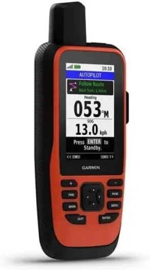
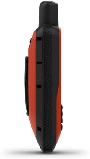
Chunky, floaty, and very much built for wet hands
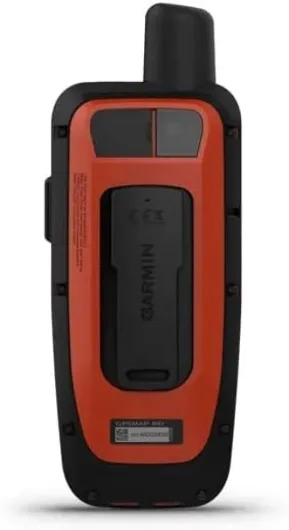
Design-wise, the GPSMAP 86i feels like a classic Garmin handheld that’s been beefed up for marine use. It’s fairly tall and thick, with big physical buttons under the screen and a rubberized back that gives enough grip when your hands are wet or cold. This isn’t a sleek gadget; it’s more like a tool you don’t worry about dropping on the deck. Personally, I prefer this kind of design at sea. I’ve tried using a phone in a waterproof case, and it’s always slippery and annoying in comparison.
The 3-inch screen is small compared to modern phones, but for a handheld GPS it’s decent. It’s not a touchscreen, which at first feels old-fashioned, but on the water it makes sense. Touchscreens with splashes and salt spray are a pain. The buttons are clearly labeled and you can use them with light gloves on. The downside is there’s a bit of a learning curve. The menu system is typical Garmin: functional, but you’ll spend some time figuring out what’s buried where. After a couple of outings I was faster, but it’s not instantly intuitive if you’re new to their stuff.
One thing I tested on purpose was the floating claim. I clipped it to a lanyard, tossed it in the water next to the dinghy, and watched. It does float, screen up, and it’s still readable in bright sun once you wipe the main droplets off. That’s reassuring. The body feels solid and sealed, and I never worried about a bit of spray or even a quick dunk. Compared to cheaper, more plastic-feeling handhelds I’ve used, this one feels more confidence-inspiring.
On the downside, it’s not pocket-friendly. In shorts or light trousers it feels bulky and heavy. It’s more something you clip to a life jacket, lash to the cockpit, or keep in a grab bag. Also, there’s no real built-in carabiner-style clip like some hiking models; you’ll probably want to add a proper lanyard or float strap. Overall, the design is practical for a boat, but don’t expect something you’ll casually carry around town. It’s a purpose-built brick for rough conditions, and it looks and feels like one.
Battery life: long-lasting, but real numbers are lower than the brochure
Garmin claims up to 200 hours of battery life, which sounds huge. In practice, it really depends how you use it. Over two weekends, I mostly ran it in GPS mode with the backlight at a medium setting, occasional inReach messaging, and some wireless connection to a chartplotter. In that scenario, I was seeing more like 20–30 hours of actual use per charge, not 200. The 200-hour figure is clearly under very low-power, tracking-only conditions with minimal screen time.
Still, 20–30 hours is pretty decent for a handheld doing full GPS and wireless tasks. I could easily get through a full day on the water, plus some extra time, without worrying. I charged it via USB in the cabin at night and it was ready to go the next morning. The battery indicator is fairly honest; it doesn’t suddenly drop from 50% to dead like some older devices I’ve had. You can also tweak settings like backlight timeout and tracking interval to squeeze more life out of it.
What I liked is that you don’t feel tethered to a power outlet all the time. As a backup device, that’s important: if the main boat power goes down, this thing still has plenty of juice left to get you home or at least keep track of your position and call for help. I left it on in the cockpit for roughly 10 straight hours one day, checking it periodically, and still had enough battery left that I didn’t feel forced to plug it in right away.
On the downside, the battery is not user-swappable, so you can’t just throw in spare AAs like some older handhelds. If the internal battery ages or you’re on a longer trip without charging options, you’ll need a power bank or some way to recharge via USB. For most weekend and coastal users, that’s fine. For longer offshore passages on small boats with minimal power, it’s something to plan around. Overall, the battery life is good enough for what it’s meant to do, just don’t take the 200-hour number at face value unless you’re running it in ultra-eco mode.
Built to be abused, but not indestructible
Durability is where the GPSMAP 86i feels reassuring. The waterproof and floating design is not just marketing. I had it getting splashed in the cockpit, sat it in a wet cup holder, and dunked it near the dinghy on purpose. No issues: no fog under the screen, no weird buttons, no corrosion starting around ports. The rubber covers on the ports seat firmly, and the overall shell feels tight. It’s the kind of device I don’t baby; I just wipe off the salt at the end of the day with a damp cloth.
The screen is sunlight-readable, but like any exposed display on a boat, it will pick up small scratches if you’re rough with it. I tossed it in a bag with some other gear once and noticed a couple of tiny marks after. Nothing dramatic, but if you’re picky about screens you might want a cheap screen protector. The buttons feel solid, with a clear click, and didn’t show any sticking or mushiness after getting salt water on them. That’s better than some cheaper handhelds I’ve tried where the rubber keys start feeling weird pretty quickly.
I also dropped it from about waist height onto the cockpit floor (by accident), and it survived with just a tiny scuff on the plastic. No cracks, no glitches. It’s not rated as a hardcore drop-proof brick, but for normal boat use—banging around on a bench, sliding on a table, getting tossed between people—it holds up fine. The weight and shape help; it doesn’t feel like it’s going to shatter if it hits something.
Long term, the main concern I’d have is the internal battery aging and maybe the rubber port cover loosening after years of use. But that’s speculation based on other gear; in my short test, everything stayed tight. Compared to relying on a phone in a cheap waterproof case, this feels much more durable and purpose-built. It’s not unbreakable, but for regular boating, fishing trips, and occasional rough weather, it feels like it can handle a fair bit of abuse without complaining.
GPS accuracy, marine features, and inReach in real use
In terms of GPS performance, I had no real complaints. It locked onto satellites quickly when turning it on in the marina, and I didn’t notice any weird jumps or big position errors while under way. Speed over ground and track lines matched what we saw on the fixed chartplotter almost perfectly. This is what you want from a backup: boring, predictable accuracy. The device supports standard GPS and did fine even when I was tucked under a small canopy on the fishing boat.
Using it as a marine tool, it’s clearly better once you load proper BlueChart g3 charts. I borrowed a card for one weekend, and having decent depth contours, buoys, and navigation aids made a big difference. Without that, the base maps are usable but not great for detailed coastal navigation. The ability to stream boat data from a compatible Garmin chartplotter is actually handy: I could walk to the bow and still see speed, depth, and heading on the handheld. That’s a nice perk when you’re anchoring or checking clearance.
The inReach satellite messaging worked, but it’s not fast like normal texting. Messages took a couple of minutes to send and receive, depending on sky view. I sent test messages to my phone and to a friend; everything arrived, and the replies came back fine. The interface for composing text with buttons is a bit tedious, like using an old T9 phone, but for short messages like “All good, ETA 6 pm” it’s acceptable. The SOS function is something I thankfully didn’t test for real, but the setup and status screens are clear, and it’s obvious when tracking and SOS are armed.
Overall, performance is solid but not mind-blowing. It does what it says: reliable GPS, decent marine integration, and working satellite comms. Just keep in mind the full potential depends on extra spending (charts, subscription) and being in a Garmin-heavy setup. If your boat runs another brand of electronics, you lose some of the neat integration and it becomes more of a standalone GPS plus SOS beacon.
What the GPSMAP 86i actually does (and doesn’t do)
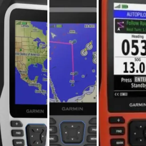
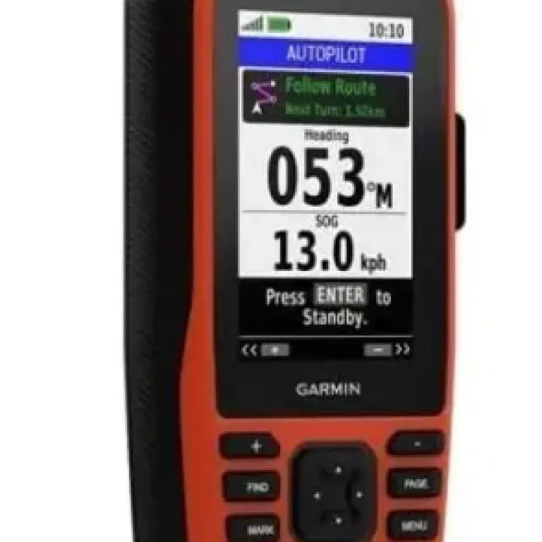
On paper, the GPSMAP 86i is a handheld marine GPS that floats, shows charts, connects wirelessly to your boat electronics, and adds inReach satellite messaging and SOS over the Iridium network. Out of the box, you basically get the device, a charging/data cable, and that’s it. No fancy mount, no extra accessories. It’s 272 grams, so not super light but still fine in one hand, and the 3-inch screen is about the size of a small smartphone screen, just in a chunkier body with physical buttons.
Function-wise, it supports optional BlueChart g3 charts, which means the really useful marine cartography is an extra purchase if you don’t have it already. Without that, it’s more of a basic GPS with a map rather than a proper chartplotter replacement. It also acts as a remote control for compatible Garmin autopilots and Fusion marine audio, which is nice if your boat is already full of Garmin gear. I tried the remote autopilot control on a friend’s boat and it worked, but you do have to get used to the button layout instead of a touchscreen.
Where it stands out from a normal handheld GPS is the inReach side: you can send and receive text messages anywhere with a view of the sky, share your position, and trigger an SOS that goes through GEOS. That’s the main reason someone would pick this over a cheaper handheld. But you need a separate subscription, and the plans aren’t free. So you’re committing to a monthly or yearly cost on top of the already not-so-low purchase price.
In practice, I ended up using it for three main things: checking position/speed/track when moving around the boat, sending a couple of satellite messages to test the service, and keeping it powered on as a backup navigation tool in case the main plotter or power system failed. For those jobs, it gets the job done. Just be aware you’re buying into a Garmin-centric, subscription-heavy gadget. If you just want GPS for a kayak on a lake, this is probably overkill.
Pros
- Floats and is properly waterproof, with a bright 3-inch screen usable in full sun
- Reliable GPS performance and good integration with Garmin chartplotters and autopilots
- Built-in inReach satellite messaging and SOS for real offshore safety, assuming you pay for a plan
Cons
- High overall cost once you add BlueChart g3 charts and inReach subscription
- Bulky, button-based interface with a learning curve and no user-replaceable batteries
Conclusion
Editor's rating
After using the Garmin GPSMAP 86i on several trips, my take is pretty straightforward: as a marine backup GPS with real satellite SOS, it does its job well. The GPS accuracy is solid, it floats, it’s readable in bright sun, and it feels built for rough, wet conditions. The inReach messaging and SOS add real peace of mind once you’re out of cell range, and the integration with Garmin chartplotters and autopilots is genuinely useful if your boat is already running Garmin gear.
On the flip side, it’s not a cheap toy. You’re paying a decent chunk for the device, then more for BlueChart g3 charts if you want proper marine mapping, and then a recurring inReach subscription if you actually plan to use the satellite side. The interface is functional but not super intuitive at first, and the device is bulky enough that it’s clearly made for the boat, not for daily carry. Battery life is good but not close to the ideal 200-hour figure unless you run it in very low-power modes.
If you’re a cruiser, offshore sailor, or serious angler who wants a tough, floating backup GPS with emergency comms, this is a pretty solid option and the price is easier to swallow. If you mostly potter around near shore with good cell coverage, it’s probably overkill and you can get by with cheaper solutions. Overall, I’d rate it as a good, reliable tool with a few annoyances and a price that makes sense only if you really use what it offers.