Summary
Editor's rating
Is the 79sc worth the money?
Chunky, practical, and built to get wet
Battery life: good enough, but not endless
Built to survive spray, drops, and general boat abuse
GPS lock, charts, and real-life navigation
What you actually get out of the box
Pros
- Rugged, floating design that actually feels built for real marine use
- Preloaded BlueChart g3 coastal charts turn it into a true handheld chartplotter
- Fast and reliable GPS lock with good screen visibility in bright sunlight
Cons
- Interface feels old-school and takes time to learn
- Some reports of units shipping without the advertised BlueChart maps
- Battery is good but not great for multi-day trips without charging
Specifications
View full product page →| Brand | Garmin |
A floating safety net in your hand
I’ve been using the Garmin GPSMAP 79sc as a backup GPS on a small sailboat and a fishing skiff, so this is coming from actual time on the water, not just unboxing it on the couch. I wanted something that floats, shows my position clearly in bright sun, and doesn’t die halfway through a long day. My main chartplotter is fixed at the helm, so this handheld is more of a safety net and a tool for dinghy runs and quick checks away from the main screen.
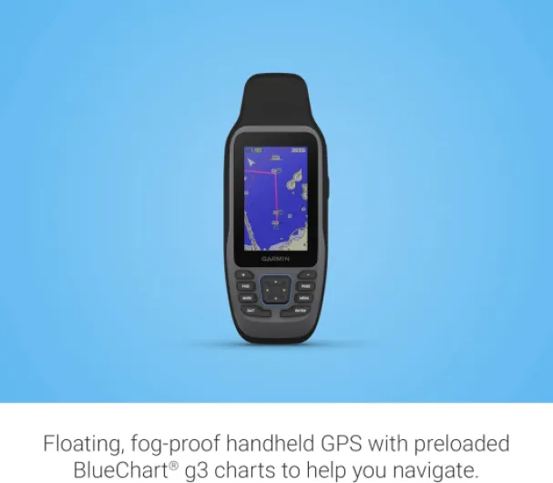
The hook with this model is pretty simple: it floats, it’s rugged, and it comes with BlueChart g3 coastal charts already loaded. On paper that means you take it out of the box, power it up, and you have marine charts right away. In practice it’s almost that simple, but there are a few catches, especially around how the menus are laid out and how Garmin explains things (spoiler: they don’t, much).
After a couple of weeks, what stood out most to me was that the hardware is solid, the GPS lock is fast, and the screen is actually readable in bright sunlight. The flip side is that the interface feels a bit dated and clunky, and you’ll probably spend a few evenings poking around menus or reading the manual PDF. If you expect smartphone-style ease of use, you’ll be annoyed at first.
Overall, I see the 79sc as a tool you buy for reliability and redundancy, not for a slick experience. It does its job: it tells you where you are, lets you follow routes, and survives getting wet. But between the mixed experiences with preloaded charts and the learning curve, it’s not perfect. Good backup unit, decent primary handheld if you’re willing to put some time into it.
Is the 79sc worth the money?
Value-wise, the GPSMAP 79sc sits in a slightly awkward spot. You’re paying a premium over the basic handheld GPS units mainly for two things: preloaded BlueChart g3 coastal charts and the marine-focused design (floating, rugged, proper water resistance). If you actually use those charts and want a dedicated marine backup, the price makes sense. If you just want a simple GPS to show coordinates, there are cheaper Garmin models that will do the job.
The issue is that at this price, you start getting close to entry-level fixed chartplotters, which have bigger screens and nicer interfaces. But of course those don’t float and can’t go in the dinghy or be carried around the deck. So you have to be clear about what you’re paying for: portability and redundancy. As a second layer of navigation behind a main plotter and paper charts, I think the 79sc is a reasonable investment, especially for small boats and people who sail or fish a lot.
Where the value takes a small hit is the inconsistent experience with preloaded charts and the weak documentation. If you’re unlucky and get a unit without the promised maps, you’ll be understandably annoyed, because that’s a big part of what you’re paying for. Also, the learning curve means you’re investing not just money but time. If you’re not the type who likes to tinker and read manuals, you might end up underusing what you paid for.
Overall, I’d call the value good but not spectacular. It’s not a bargain, but it’s not a rip-off either. If you need a rugged, floating handheld with real marine charts and you’re okay dealing with a slightly old-school interface, the price is justified. If your boating is very casual or mostly on well-known lakes and rivers, you might be better off with a cheaper handheld or even a phone app plus a waterproof case.

Chunky, practical, and built to get wet
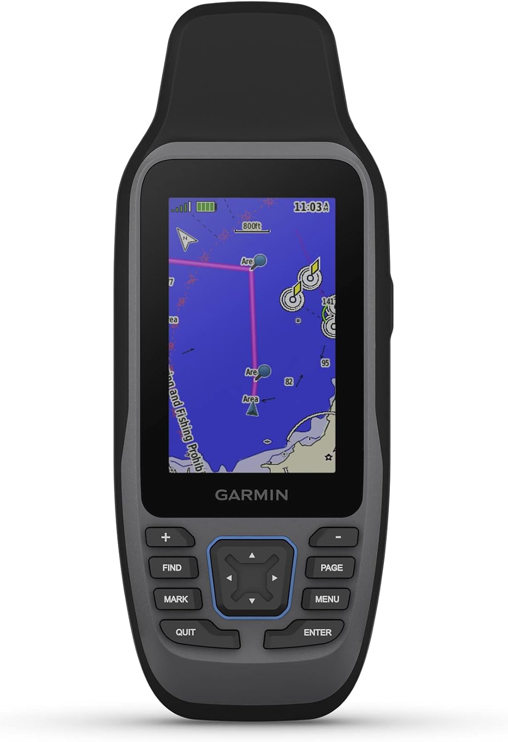
The design is very much “marine tool”, not “sleek gadget”. The GPSMAP 79sc is chunky in the hand, with a rubberized outer shell and a layout that feels like the older Garmin handhelds. It’s not tiny, but that’s actually good on a boat: you can grab it with wet hands or gloves and not feel like you’re going to drop it. At about 282 grams, it has some weight, but it’s not heavy enough to be annoying hanging from a lanyard around your neck.
The buttons are where the age of the design shows. There’s no big touchscreen interface like on a phone; you have physical buttons and a directional pad at the bottom. Personally, I like that on the water because touchscreens with wet fingers are a pain. The downside is that some of the buttons feel a bit too sensitive, especially when you’re trying to scroll through menus or zoom the map. One of the reviewers mentioned the “scrolling buttons are a bit touchy,” and I agree. You overshoot menus sometimes, which is mildly irritating but not a dealbreaker.
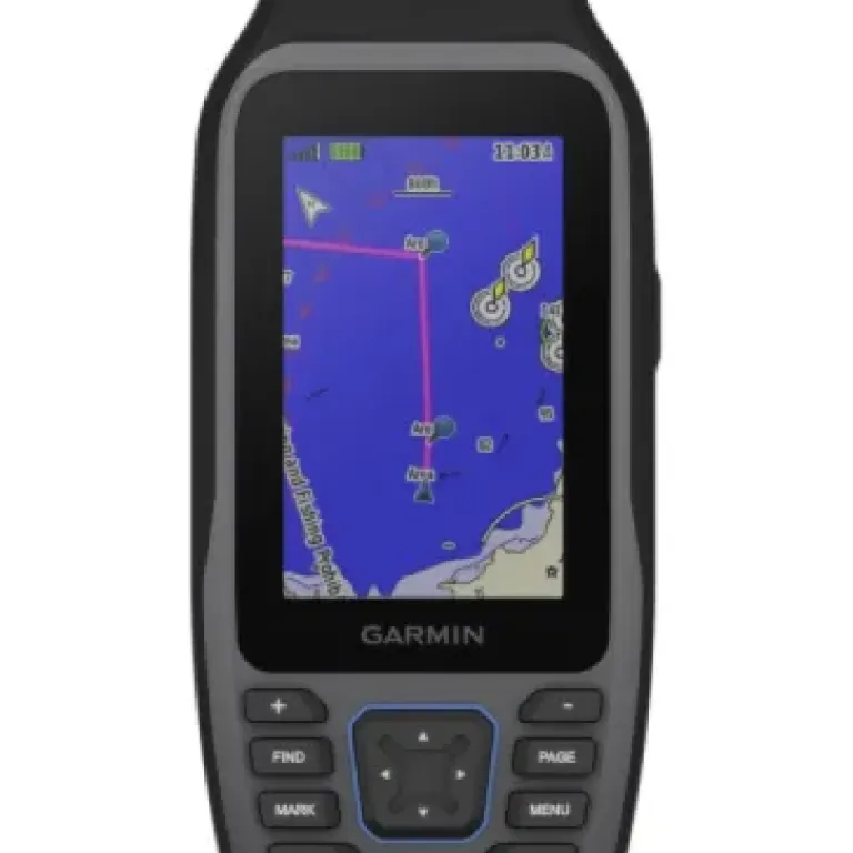
The screen is a 240 x 400 color display, and while those numbers are nothing special by smartphone standards, it does its job well in bright sun. That’s what matters out there. I had it side by side with an older unit and the difference in clarity and brightness was obvious. The screen is also described as fogproof and scratch-resistant. I haven’t managed to scratch it yet despite tossing it into a bag with other gear, so I’d say the material is holding up fine so far.
The main design feature that really matters is that it floats. I didn’t intentionally throw it overboard for fun, but I did drop it into a bucket of water and it bobbed right back up. That’s the kind of thing you hope you never need, but if you do, you’ll be happy it’s there. Overall, the design is not pretty, but it’s practical. It feels like something you can abuse a bit, and that’s what I want in a marine handheld.
Battery life: good enough, but not endless
Garmin quotes around 19 hours of battery life, and that’s roughly what I saw in real use. With the backlight at a reasonable level (not maxed), GPS on the whole time, and some occasional route tweaking, I was getting a long full day and still had some juice left. One reviewer said the predicted 19 hours seemed accurate but wished it was 24, and I’m in the same boat: it’s fine, but an extra few hours would make multi-day trips simpler.
For how I use it – as a backup and for dinghy runs – 19 hours is workable. I just got into the habit of topping it up via USB at the end of the day. If you’re planning to rely on it as your main navigation device on a multi-day trip without power, you’ll either need to carry a power bank or turn it off when you don’t absolutely need it. It’s not a set-and-forget for a whole weekend unless you’re very careful with screen brightness and usage.
The fact that it’s rechargeable rather than AA batteries is a double-edged sword. On one hand, it’s convenient: plug it into any USB port on the boat or a power bank, and you’re good. On the other hand, you can’t just swap in fresh AAs if you forget to charge it. For some people that’s a big downside, especially if you’re used to older Garmin handhelds that ran on standard batteries. Personally, I’d prefer the option for AAs in a true backup device, but I can live with the internal battery setup here.
In short, the battery is decent but not more than that. It fits day trips perfectly, and it’s manageable on longer cruises if you plan your charging. If you expected it to run for days without a cable, you’ll be a bit disappointed. But it doesn’t die unexpectedly, and the charge estimate is honest, which is already better than a lot of devices.
Built to survive spray, drops, and general boat abuse
Durability is one of the main reasons to pay Garmin money for a marine handheld instead of trying to use your phone in a cheap waterproof case. The 79sc feels like it was built for rough handling. The rubberized outer shell gives decent impact protection, and the whole body feels rigid, not hollow or flimsy. I’ve dropped it on the cockpit floor a couple of times and tossed it in and out of a dry bag, and it still looks basically new.
Water resistance is obviously key here. I’ve used it in spray, light rain, and with wet hands, and it didn’t flinch. The ports are covered properly, and there’s no sign of moisture under the screen. I haven’t fully submerged it for long periods, but given that it floats and is marketed as a marine device, it’s clearly built with that in mind. One reviewer said they’d “wait to test” the floating part until they drop it overboard by accident, which is fair – but the physics check out, and my bucket test was fine.
The screen is marketed as scratch-resistant and fogproof. I can’t say much about fogproof since I haven’t had it in very cold-to-hot transitions, but I can say it hasn’t scratched easily. I kept it in a pocket with keys for a short dinghy ride by mistake and expected at least a light mark, but nothing obvious showed up. Long term, I’d still probably throw a cheap screen protector on it if I was going to use it heavily, but out of the box it holds up better than a typical phone screen.
Overall, in terms of durability, it feels like a proper marine tool, not a delicate gadget. That doesn’t mean it’s indestructible, but for normal boating abuse – bumps, spray, being tossed around – it handles it fine. If your main concern is “Will this survive a season on the boat?”, my honest answer is yes, it probably will, as long as you don’t actively try to kill it.
GPS lock, charts, and real-life navigation
On performance, the 79sc is pretty solid where it counts. GPS lock is quick – usually just a few seconds from cold start, even after it’s been off for a while. One reviewer called it “almost instantaneous,” and that lines up with what I saw. It hooks into multiple satellite constellations, and I never had it lose position even under a bimini or close to a cliff. For coastal and inshore use, that’s more than enough.
The BlueChart g3 coastal charts are the main reason to get the “sc” version. In my area, detail is decent: buoys, depth contours, channels, marinas, all the basics you need. It’s basically like having a small chartplotter in your hand. That said, the experience depends a lot on how comfortable you are with Garmin’s map screens. Zooming and panning with the buttons is slower than on a touch device, and if you’re trying to do fine adjustments in choppy water, you’ll sometimes overshoot and have to go back and forth. Not the end of the world, but a reminder this is a tool, not a toy.
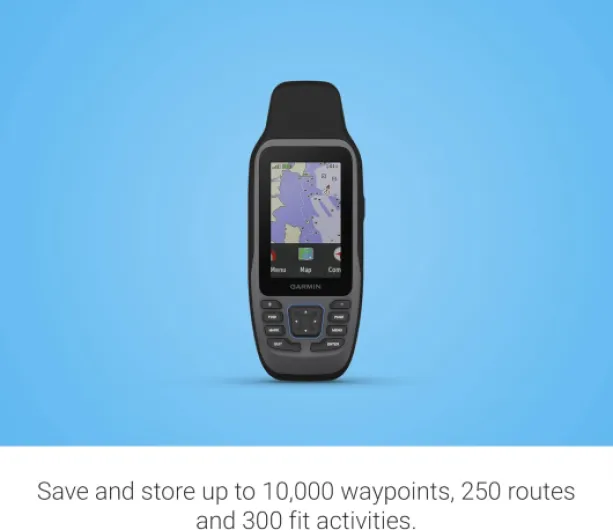
Where the 79sc shines is waypoint and route handling. With the 10,000 waypoint and 250 route capacity, you can store a lot of fishing spots, anchorages, and tracks from previous trips. I imported a few standard routes and then recorded a couple of long days of sailing; the track recording was clean and reliable. No weird jumps or gaps. One reviewer mentioned using it for NMEA output to an autopilot; I didn’t test that integration in depth, but the presence of the round Garmin power/data port means it’s not just a standalone toy – it can slot into a more serious setup if you know how.
The main weakness in performance is not the hardware but the user interface. Some functions are buried in menus, and Garmin doesn’t really guide you through them. You can do a lot with this device, but you’ll need patience to unlock it. Once you’ve set up your main pages and figured out where things live, it behaves well and does the job reliably. No crashes, no weird freezes, just a slightly old-school way of doing things.
What you actually get out of the box
Out of the box, the Garmin GPSMAP 79sc is pretty straightforward. You get the unit, a USB cable, a lanyard, and the usual thin quick-start booklet that barely tells you anything. No charger brick, no fancy case, nothing extra. For a marine GPS at this price, that’s pretty standard, but don’t expect a full kit. I ended up buying a small padded pouch separately because I didn’t want it banging around in a locker.
The big selling point on the box is “Preloaded BlueChart g3 coastal charts”. On my unit, the charts were there and up to date enough for what I do (coastal cruising and inshore fishing). But one of the Amazon reviews mentions getting a unit with no BlueChart at all, which is pretty annoying if you’re paying specifically for that. So there’s clearly some inconsistency in what people receive, or maybe older stock that wasn’t set up right. If you buy it for the charts, I’d check that the coverage you need is actually installed the first day you turn it on.
The menus are packed with features: waypoints, routes, tracks, trip data, compass, tides, and even NMEA output if you know what you’re doing. The problem is Garmin doesn’t explain half of it in the quick guide, and the detailed manual is a PDF you have to download. So the real presentation is: you get a capable device that feels a bit “figure it out yourself.” If you’ve used older Garmin handhelds like the GPSMAP 76 series, you’ll be at home. If this is your first marine GPS, be ready to experiment.
In short, what you’re buying here is a standalone handheld chartplotter with a lot of depth, not a polished consumer gadget. It feels like a tool built by engineers for people who already know the Garmin logic. Once you get past that, the feature set is decent for the size: 8 GB memory, up to 10,000 waypoints and 250 routes, and charts that are good enough for serious navigation, not just a rough map. But don’t expect any hand-holding from the documentation.
Pros
- Rugged, floating design that actually feels built for real marine use
- Preloaded BlueChart g3 coastal charts turn it into a true handheld chartplotter
- Fast and reliable GPS lock with good screen visibility in bright sunlight
Cons
- Interface feels old-school and takes time to learn
- Some reports of units shipping without the advertised BlueChart maps
- Battery is good but not great for multi-day trips without charging
Conclusion
Editor's rating
The Garmin GPSMAP 79sc is a reliable, no-frills marine handheld that focuses on doing the basics well: it knows where you are, shows you proper coastal charts, survives getting wet, and floats if you drop it. The hardware feels tough, the GPS lock is quick, and the screen is readable in bright sunlight, which is what really matters on a boat. Battery life around 19 hours is decent for day trips and manageable for longer outings if you plan your charging. In short, as a backup or portable chartplotter, it gets the job done.
On the downside, the user interface is dated and not very intuitive at first. You’ll probably have to dig into the online manual and spend some time exploring menus to unlock all the features, like routes, tracks, and NMEA output. There are also reports of some units not actually having the BlueChart maps preloaded as advertised, which is frustrating given that the charts are a big part of the price. So it’s not perfect, and there are cheaper options if you don’t need marine charts or a floating device.
I’d recommend the 79sc to sailors and anglers who want a serious backup navigation device or something portable to complement a main chartplotter. It’s also a good fit for small-boat owners who don’t have space or budget for a fixed unit but still want proper charts. If you’re more of a casual boater, or if you hate fiddly menus and learning curves, you might be happier with a simpler GPS or just a good navigation app on your phone in a waterproof case. This Garmin is a tool for people who are okay putting in a bit of time upfront to get a reliable companion on the water.