Summary
Editor's rating
Is it good value or should you save for a bigger brand?
Old-school look, functional layout
Power draw and real-life usage on a 12 V system
Waterproofing, build, and how it handles real conditions
Positioning, maps and day-to-day use on the water
What you actually get in the box
Pros
- Stable and accurate GNSS positioning with GPS + BeiDou support
- Large storage for waypoints, routes and tracks (more than enough for casual use)
- Comes with external antenna, cables and bracket so you can install it without buying extras
Cons
- Interface and documentation are clunky and feel dated
- Map/dual-map system and updates are not clearly explained and less user-friendly than big brands
Specifications
View full product page →| Brand | EVGATSAUTO |
A budget chartplotter for people who just want a GPS on the dash
I put this EVGATSAUTO marine chart plotter on a small fishing boat that I use on lakes and a bit of coastal cruising. I wasn’t looking for anything fancy, just something to show position, tracks, and basic charts without spending the same price as a used outboard. This one caught my eye because of the dual GPS/BeiDou positioning, the big waypoint capacity, and the fact it comes with the GNSS antenna and all the wiring in the box.
Right away, it’s clear this is more of a no-frills, functional unit than a polished premium device. The interface feels a bit old-school, and the operating system is Windows CE, which already tells you it’s not the latest tech. But if you’ve used older plotters before, you’ll get the idea quickly enough. It boots, it locks onto satellites, and you see your boat on a map. That’s basically what I wanted to test.
I used it over a couple of weekends, roughly 4 outings of 3–5 hours each. Weather was mixed: one rainy, one with a lot of spray and chop, and two sunny days. That gave me a decent idea of the waterproofing, screen visibility, and general reliability. I wired it directly to the boat’s 12 V system and mounted the external antenna on the rear rail.
To be blunt: it’s not perfect, and there are clear signs you’re dealing with a budget Chinese unit, especially with the software polish and documentation. But it does the job for navigation, and for the price bracket it sits in, I’d say it’s a reasonable option if you know what you’re getting into and don’t expect Garmin or Raymarine level refinement.
Is it good value or should you save for a bigger brand?
Price-wise, this EVGATSAUTO plotter sits in that space where it’s cheaper than Garmin/Raymarine/Lowrance 7-inch units, but more expensive than a basic handheld GPS. For the money, you get a full fixed-mount chartplotter with external antenna, Wi-Fi, a big waypoint/track capacity, and decent GNSS performance. So on paper, the value looks good, especially if you just want reliable positioning and simple chart display without extras.
Where you feel the lower price is in the software polish, documentation, and ecosystem. There’s no slick app integration, no big map store, and not much guidance on adding or updating charts. If you’re comfortable tinkering a bit and don’t mind a slightly clunky interface, you can live with that and save money. If you want something you just plug in and instantly have detailed local charts and an intuitive UI, you might be happier paying more for a mainstream brand.
Compared to a used older-brand unit, this one has the advantage of new hardware, warranty, and better GNSS sensitivity, but it lacks the brand support, known chart options, and long-term update path. Personally, for a small lake boat or occasional coastal use, I think the value is decent. It gets the job done, and you’re not terrified of it getting stolen or damaged because it didn’t cost a fortune. For a larger boat or someone doing serious offshore trips, I’d treat this more as a backup or secondary plotter rather than the main brain of the boat.
So in terms of value, I’d rate it as good but not outstanding. You’re trading polish and support for lower cost and adequate performance. If that trade-off sounds fine to you, you’ll probably be satisfied. If you’re the type who hates fighting with menus or manuals, consider stretching the budget for a more user-friendly system.
Old-school look, functional layout
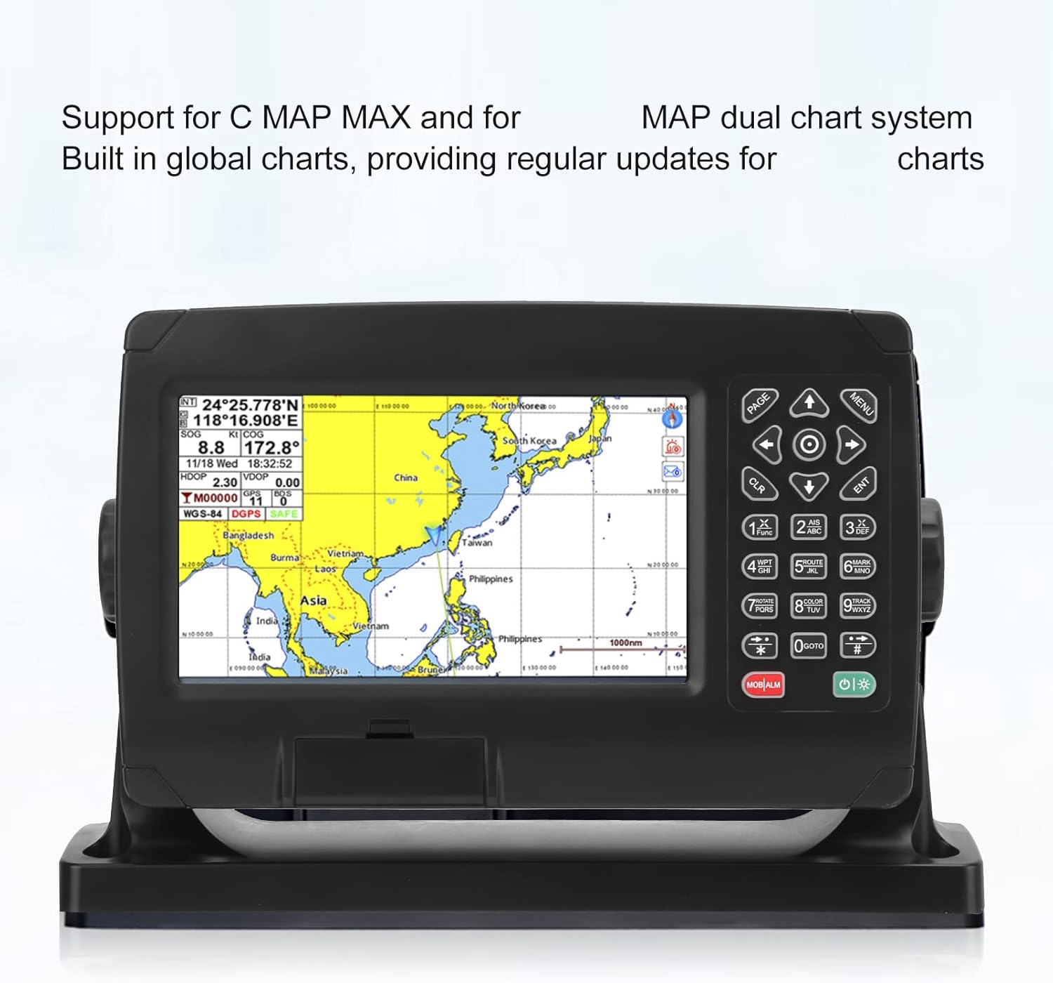
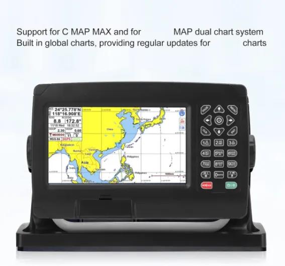
Design-wise, this plotter looks like something from about 8–10 years ago, and that’s not necessarily a bad thing. The 7-inch LCD (800x480) is big enough to read charts and data without squinting, but don’t expect super crisp or high-contrast graphics. The colors are fine, the fonts are legible, and the map redraw speed is acceptable. It’s not pretty, but it’s usable. For a boat where function matters more than aesthetics, I didn’t mind it.
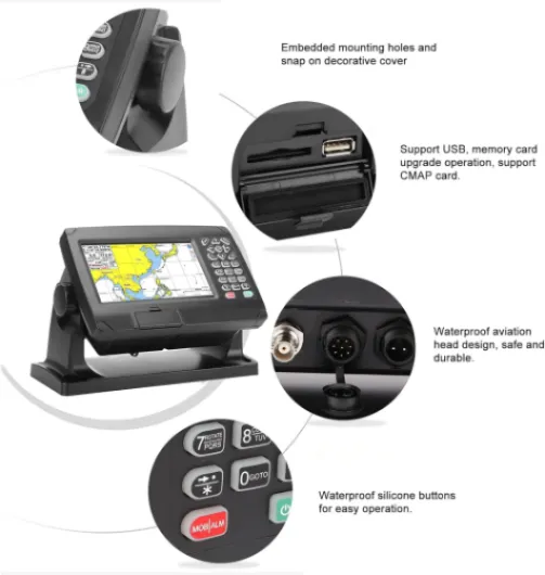
The plastic housing feels decent. Not super premium, but not flimsy either. The bracket holds the unit firmly, and the side knobs tighten well enough that it doesn’t move even when the boat slams through chop. I tried tilting and adjusting it a few times while underway and it stayed where I put it. The back has the ports for power and data cables, plus the antenna connector. They’re all grouped together, so cable management is straightforward, but it does create a bit of a bulk of wires behind the unit.
The touchscreen is capacitive, which is nice compared to older resistive screens. It responds better to finger taps and swipes, but you do lose some responsiveness with wet fingers or gloves. In light spray, it was still usable, but when the screen had a lot of water droplets, some taps didn’t register properly. I ended up wiping it with a cloth now and then. There are no hardware buttons for navigation, which I kind of miss; in rough seas, physical buttons are easier than a pure touch interface.
One design detail I liked: you can customize how your boat icon is displayed on the screen, and where it sits (centered or offset). That sounds minor, but being able to push your boat icon slightly lower on the screen gives you more map ahead of you, which is useful when following channels or avoiding shoals. It’s a small touch that actually helps in real use. Overall, design is practical, a bit dated visually, but it gets the job done without trying to be fancy.
Power draw and real-life usage on a 12 V system
This unit doesn’t have an internal battery, so it’s meant to be wired directly to your boat’s 12 V system. That’s pretty standard for fixed chartplotters. They don’t give a super clear power consumption spec in the listing, but based on my setup and how my battery monitor behaved, I’d guess it pulls in the ballpark of 0.5–0.8 A at 12 V with brightness at a medium-high level. On my small boat with a 70 Ah battery and a modest alternator, it barely made a dent over a few hours of use.
Boot time is reasonable: from power on to usable map takes maybe 30–45 seconds. Not lightning fast, but acceptable. I usually power it up while I’m still at the dock getting lines sorted, so by the time I’m leaving, it’s ready. There’s no fancy low-power or sleep mode like on some newer units; you just turn it on and off with the switch or breaker. I didn’t notice any weird spikes or resets when starting the engine, so the internal power regulation seems okay.
Because there’s no built-in battery, you do need to think about your overall power management if you run a small boat without charging. On a full day with the GPS, fishfinder (separate unit), VHF, and phone charging, I still had plenty of juice left. If you’re in a kayak or a micro skiff relying on a tiny standalone battery, you might want to test the draw yourself or use a dedicated small lithium pack. But for most regular boats with a standard 12 V system, this is not a heavy load.
In short, on the power side it’s boring in a good way: it turns on, it runs, it doesn’t do anything surprising. Just make sure your connections are clean, use the correct fuse, and you’re fine. If you’re looking for a portable unit with its own battery, this is not it. It’s clearly designed to live on the console and feed off the boat’s system like any other fixed marine electronics.
Waterproofing, build, and how it handles real conditions
The unit claims IPX6 waterproofing, which basically means it should handle strong water jets but not full submersion. In practice, on my open boat, it took spray, some rain, and a few direct splashes when hitting wakes. I didn’t baby it. After several hours of this, no fogging behind the screen, no weird condensation, and all functions still worked. I did not dunk it underwater (obviously), but for typical marine use on the console, I’d say the waterproofing is fine.
The plastic shell is sturdy enough. I didn’t see any flex or creaking when tightening the bracket or plugging cables in. The back connectors have rubber seals and the cables seat firmly. I still recommend putting a bit of dielectric grease on the connectors, as with any boat electronics, just to help with corrosion over time. The external antenna is small and light; I mounted it on a rail using a generic bracket, and it hasn’t moved. The cable feels okay, not super thick, but not fragile either.
Heat dissipation is something they mention, and I did notice the unit gets warm on the back but never hot. One of the outings was in full sun, about 28–30°C, and the screen stayed readable. There was some glare, but that’s true of most non-anti-glare screens. I didn’t see any brightness drop or weird color shifts from heat. Long-term, I can’t guarantee how it will handle years of UV and salt, but in the short term it seems fine. This is one of those products where regular rinsing with fresh water and a cover when not in use will probably make a big difference.
Overall, I’d call the durability pretty solid for the price but not bulletproof. It feels more like a budget fishfinder/plotter than a heavy-duty commercial unit. If you’re a weekend boater or casual fisherman, it should hold up if you treat it reasonably. If you run a workboat or charter in rough conditions every day, I’d spend more on a brand with a track record for long-term abuse. Nothing in this unit screams "fragile", but nothing screams "built for war" either. It sits somewhere in the middle.
Positioning, maps and day-to-day use on the water
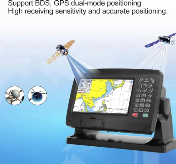
On the water, the GNSS performance is probably the strongest part of this unit. It picks up satellites quickly after boot, usually within a minute from cold start, and much faster once it has already been on that day. The dual GPS/BeiDou support seems to help with stability; I rarely saw the position jump or drift, even when moving slowly in a marina. Speed over ground (SOG) and course over ground (COG) were stable enough for basic navigation and trolling. I compared it to my phone’s GPS app and an older handheld, and this one was consistently the most stable.
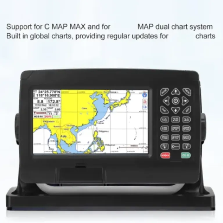
Map-wise, it’s a bit more complicated. They talk about a dual map system and satellite map coverage, but out of the box, the cartography is basic. It’s usable for general positioning, but don’t expect super detailed depth contours like you’d get with Navionics or C-MAP on a high-end unit. Depending on where you are, you might need to mess around with extra map files or SD cards (not included) to get good local charts. The manual doesn’t explain this clearly, and that’s probably the most frustrating part for a non-tech user.
Routing and waypoints work fine. I created a few routes along the coast and through some markers on a lake. The unit followed them without any weird behavior, and the track logging works as advertised. It happily recorded multiple hours of tracks and let me view them later. The sheer capacity (thousands of tracks and millions of points) is way beyond what most casual boaters will ever use. The interface for managing those tracks and routes is a bit clunky though: lots of lists and submenus, and the naming process isn’t very intuitive.
The Wi-Fi connectivity is present on paper, but it’s not like a modern connected ecosystem where you sync to a phone app. It’s more for configuration or potential firmware updates, and again, the documentation is thin. I didn’t see any easy way to pull routes from a phone or tablet. So if you’re expecting a fully connected navigation system, this isn’t it. In daily use, though, as a standalone GPS/chartplotter, it performed reliably and never froze or rebooted on me during the test outings, which is what matters most.
What you actually get in the box
Out of the box, you get quite a bit: the 7-inch chartplotter, an external GNSS antenna, an 8-core data cable, a 2-core power cable, mounting bracket, knobs, screws, and a basic manual. So at least you’re not chasing random connectors or brackets. I wired it to a simple switch panel, and the power cable length was enough for a small boat. For a bigger cabin cruiser you might need to extend it, but that’s normal.
The manual is where you first feel the budget side. It’s readable, but the English is clunky and some steps are vague. For example, the way they explain setting up custom waypoints and routes is not very clear. I ended up just pressing buttons and figuring it out myself. If you’re not comfortable poking around menus, this might annoy you. On the plus side, the menus are fairly logical once you dig in: map, waypoints, routes, tracks, system settings. Nothing too hidden.
The unit claims support for 50,000 waypoints, 50,000 marks, 500 routes, and 1,000 tracks with up to 1.6 million track points. Obviously I didn’t max that out, but I did import a decent number of test waypoints and let it record tracks for several hours. It never complained about memory or slowed down in any noticeable way. For a weekend user or small charter, that capacity is more than enough. You’re not going to hit those limits unless you’re logging every trip for years.
They also advertise dual-mode GNSS (GPS + BeiDou) and some self-developed SOG/COG filtering. In practice, what that means is the position and speed readouts are pretty stable and don’t jump around much, even at low speeds. Compared to an older GPS-only handheld I had on board, this one locked on quicker and the course-over-ground was less jittery when trolling slowly. So from a pure navigation standpoint, the core functions are solid, even if the presentation is a bit dated.
Pros
- Stable and accurate GNSS positioning with GPS + BeiDou support
- Large storage for waypoints, routes and tracks (more than enough for casual use)
- Comes with external antenna, cables and bracket so you can install it without buying extras
Cons
- Interface and documentation are clunky and feel dated
- Map/dual-map system and updates are not clearly explained and less user-friendly than big brands
Conclusion
Editor's rating
After using the EVGATSAUTO marine chart plotter for a handful of real outings, my take is pretty straightforward: it’s a functional, budget-friendly plotter that covers the basics well enough, but it’s not trying to compete with the big brands on polish or features. The GNSS performance is solid, the screen is readable, and the waterproofing held up fine to spray and rain. For simple navigation, following tracks, and dropping waypoints on lakes or nearshore waters, it gets the job done without drama.
Where it falls short is mostly in user experience. The interface is a bit dated, the manual is rough, and the whole map/dual-map story isn’t clearly explained. Wi-Fi is there but not in the modern "sync with your phone" way many people now expect. If you like plugging things in and having them be instantly obvious, you might find this one a bit annoying at first. It’s also not the unit I’d pick as the main navigator for serious offshore cruising or commercial use.
I’d recommend it to budget-conscious boaters with small to mid-size boats who want a fixed plotter for weekend fishing, day trips, or basic coastal runs, and who don’t mind spending a bit of time learning the menus. If you want slick integration, top-tier charts, and long-term brand support, you’re better off saving for a Garmin/Raymarine/Lowrance setup. But if you just want a straightforward GPS/chartplotter that doesn’t empty your wallet, this EVGATSAUTO is a reasonable option.